1. Project status
Quang Tri Airport Project has been included (1) Air Transport Development Plan for period to 2020 with vision to 2030 - Decision 236/QD-TTg dated 23 February 2018, and (2) Approval for Priority Projects for investment for period 2010-2020, Quang Tri Province Socio-Economic Development Master Plan - Decision No. 321/QD-TTg dated 2 March 2011. Both documents were approved by the Prime Minister.
The Aviation Department has recently submitted the Project Detailed Plan to the Ministry of Transport for consideration and approval for implementation.
Land Use Planning has been approved by the Quang Tri People's Committee. The project land has been marked out and handed over to the local authorities in 2009. This is to minimize land acquisition and hence cost.
2. Project details:
2.1. Location and area
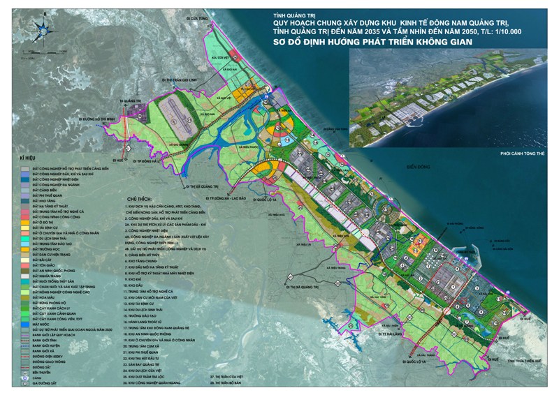
- Location: Gio Quang commune, Gio Linh district, Quang Tri province, about 7km North of Dong Ha city.
- Area: total area is 311.7ha of which the civil airport and military zone take up 50.9ha and 50.5ha respectively. The rest will be for common uses, future expansion and greeneries
2.2. Airport function and class
- Function: Domestic airport / airport
- Class: 4C-level airport as per International Civil Aviation Organization - ICAO code, for civil and class II airport for military operations
2.3. Airport design
2.3.1. Airport area (for period to 2030)
- One runway suitable for operation of aircraft ATR72, A320, A321 and similars. Length of runway is 2,600m.
- One taxiway connecting runway with apron having size of 310x150m.
- Air traffic control tower.
3.3.2. Technical Area:
- Passenger terminal with capacity of 1 million/year.
- Terminal is shared between passenger terminal and cargo terminal. New cargo terminal will be built when required.
- Airport operation office is inside passenger terminal with an area of 800m2. New operation building having an area of 7,920m2 will be built when required.
- Airport management office is inside passenger terminal. New management building having an area of 7,040m2 will be built when required.
- Rescue and fire station. Fire emergency system and equipment will be to fire level 7 as required by ICAO.
- Meteorological observation station with an area of 60m2 and garden area of about 625m2 will be built. Research and install automatic meteorological monitoring system will be built when required.
- A land area to build fuel supply area of 15,000m2 will be reserved.
- Power supply system will be from the national grid. New substation with capacity of 630KVA with standby power generator with 500KVA capacity.
- Water supply system will be built to for airport. Clean water will be from the local water supply system.
- Surface water drainage will be built
- Waste water treatment plant will be built
- Waste and garbage treatment area:
- Period to 2020. Garbage is collected and gathered in garbage trucks, taken to the local treatment area.
- For period 2020 to 2030. Waste collection area of 500m2 and a solid waste treatment plant on area of 2,500m2 will be built. Residue will be taken to waste disposal site.
- Airport security system. A suitable system will be built.
2.3.3. Flight management and administration area:
- Air traffic control (ATC) and Tower (TWR): Built right in the period until 2020, the height of the tower is not more than 43m
- Taxiway, supporting way:
- Doppler Very High Frequency Omni Directional Range/ Distance Measuring Equipment DVOR/DME: Built right in the period until 2020;
- Access light system: Research and invest when needed, the access light system meets CAT I standard at the beginning of 35 of runway, simple at the beginning of 17 of runway
2.3.4. Traffic Road Planning:
- Airport main axis: Constructing synchronously with passenger terminal. The length is about 80m, the width is at least 4 lanes and the pavement is 3m wide each side.
- Internal road: Build an internal road system with a width of road surface of 7m, a mortar of each side with a width of 3m. Road belt width 3.5m wide roadside each side 1m wide
3. Project investment cost and form
3.1. Total estimated investment cost
| No |
Item |
Total |
Period to 2020 |
Period to 2030 |
| 1 |
Construction cost |
130.2 |
70.3 |
59.8 |
| 1a |
Aviation infrastructure and facilities |
47.1 |
47.1 |
|
| 1b |
Ground service facilities |
77.8 |
20.6 |
57.2 |
| 1c |
Flight management and support |
5.3 |
2.6 |
2.7 |
| 2 |
Cost of equipment for airport operators |
19.7 |
13.8 |
5.9 |
| 3 |
Consulting costs, others |
22.5 |
12.6 |
9.9 |
| 4 |
Compensation cost |
0.3 |
0.3 |
|
| 5 |
Contingency cost |
25.9 |
14.5 |
11.3 |
| Total |
198.5 |
111.5 |
87.0 |
3.2. Expected investment form. BOT, BOO
4. Surface external connections
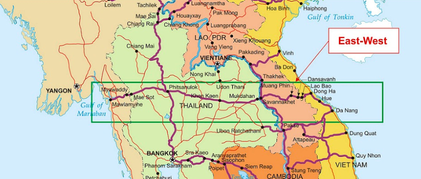
Quang Tri is the starting point of the East-West Economic Corridor which strategically, (economically and socially) connects this province with Laos, Thailand and Myanmar.
Quang Tri is on National Highway 1 and Railway, about 20km from the future Vietnam North-South Expressway and 30km from Ho Chi Minh Highway. Quang Tri is linked to the West region by National Highway 9 and National Highway 15D.
The new Airport is only 1.5km from National Highway 1 and 8km from the Dong Ha Railway Station.
Greater Mekong Subregion East-West Economic Corridor
5. Ability to serve as an aviation training center
Quang Tri Airport has a great opportunity to serve as an aviation training center for the following reasons
- Natural terrains, flat, sandy
- Favorable weather, e.g. no fog
- Large reserve of land available
Contact info:
Mr. Nguyen Duc Tan
Director
Quang Tri Investment, Trade and Tourism Promotion Agency (Quang Tri IPA)
Add: 45, Hung Vuong Street, Dong Ha city, Quang Tri Province, Vietnam
Cell: 0913474868
Fax: 0233.3852827
Email: nguyenductan@quangtri.gov.vn
tandongha@gmail.com